We’re excited to bring you the latest updates to our Geopointe platform in our Spring 2021 release! These new & updated features will further streamline your territory planning and management, as well as improve your overall user experience with our geolocation solution.
Geopointe was developed to impact your business’s bottom line and improve the efficiency and productivity of your people. With our Spring 2021 release, we’re taking territory design and management with Geopointe to a whole new level.
You need to stay organized tactically, whether that means planning ahead for expansion and diving into different markets or readjusting existing territories to accommodate staffing changes. With this in mind, we’ve focused on improving our fan-favorite Shape Editor, making it more dynamic and flexible.
Imagine if you could preview how modifications you want to make to a territory would impact the data before you finalized and saved your changes. How much time would that save you? Now, with Geopointe’s Spring release updates, you can.
And that’s just one of many updates in the Spring 2021 release.
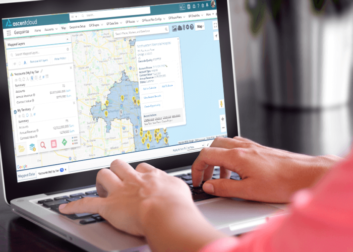
A Better Territory Planning & Management Experience

Geopointe gives organizations complete visibility into their territories and empowers them to plan and manage territories within Salesforce. It maximizes sales ops efficiency through a number of new features, including:
- NEW! Improved Shape Editor Flexibility: Easily balance your territories accurately without having to save and edit the shape repeatedly. This update allows you to display map markers and see data summaries of sub-shapes while building in Shape Editor. This makes it easier to see data before you finalize shapes, drastically cutting down the time spent on designing & maintaining territories. Think of it as more freedom to work “live” on your territories.
- NEW! Display Custom Geometric Shapes: If you’re one of the many users who have custom shapes for designating specific areas you need to reference when building territories, now you can see your custom geometric shapes on the map while building territories in Shape Editor. Previously, our Shape Editor only allowed users to build shapes from the Geopointe Shape Library. Now you have increased flexibility to work the way you want.
- NEW! Data Set Usage Report: Need help tracking adoption? Looking for a way to maintain a cleaner org by removing unused data sets? We’ve added a ‘Last Run’ field to the Data Set object, so now you can build insightful Data Set Usage Reports to see how often individual Data Sets are being used. Enable field history tracking for even deeper insight into engagement patterns to help you build successful adoption.
- NEW! Update Multiple Fields with Assignment Plans: Have complex ownership hierarchies that require custom fields for your Assignment Plans? Need to assign multiple users to be responsible for the same record? Now, Assignment Plans can populate multiple custom fields when assigning records, so that all available custom fields appear in the record editor.
- NEW! Design Enhancements: We’ve streamlined the design of two of the most frequently-used parts of the Geopointe interface. Check out the new look of our “Map Settings” window and our “Create Layer” window! Your time is precious, and we know you’ll find this new design easier & quicker to navigate.
You’ve come a long way from the old days of keeping all your data in Excel and hand drawing maps – these latest updates to Geopointe will take you another step further. These new and updated features are designed to empower users like you to do more with your CRM data, demystifying that data to surface more (and better) actionable insights.
As we continue to improve our solution for territory design & management, we’re introducing users to more flexibility in how you work with your Salesforce data.
To see these updates in action, catch the recording of our Spring 2021 Release webinar where experts walk you through the latest improvements to Geopointe.