
Geoanalytics is a powerful form of data visualization that contextualizes your CRM data and surfaces insights through geographic location. It provides a new perspective on the data you likely already have by putting your data on a map.
When your records are displayed on a map like this, it shows you the big picture. Patterns and trends become more clear, enabling instant understanding of information that would take hours to sort through in a standard report.
Because of this powerful analysis, various industries and businesses have come up with their own unique use cases for Geoanalytics software.
As providers of Geoanalytics software ourselves, we hear more unique use cases every day for how companies can use Geoanalytics software. We thought we would gather some of them up and share a few examples of real-life use cases to inspire others who are currently using – or considering using – Geoanalytics software to visualize their data.
The following are some of our favorite Geoanalytics software use cases:
1. Automatically distribute new leads to your sales reps
Use Geoanalytics software to automatically distribute and assign leads to your sales reps based on their territory boundaries and avoid confusion when territory lines move.
Some Geoanalytics software allows you to make adjustments to territory boundaries and see the immediate changes under roll-up summaries before your changes go into effect. This way, you can clearly understand how each change will affect your team and the possible strain it could put on your resources.
When territories have been adjusted, it can be difficult to keep track of who accounts should be allocated to. With the automation that is available in some Geoanalytics software, new leads or accounts will be taken care of with no effort on your part. This will save you time and ensure all customers are covered, so none slip through the cracks.
2. Determine a plan of attack for your call lists
Make sure you’re taking full advantage of every hour of your day. When you have a long call list, it’s easy to run out of time and miss some of your accounts. But you can ensure you’ve squeezed every possible call into each day with a little bit of planning.
With Geoanalytics software, you can display time zone boundaries with color-coding. This means you can quickly understand what time zone your different accounts are located in, and plan calls accordingly. For example, if you have accounts throughout the US including one in California, one in Colorado, and two in Michigan, you can start with the later time zone and still be able to make calls after hours in your time zone to the accounts that are an hour or two behind.
Take things a step further with advanced analysis techniques that help you prioritize your calls. Geoanalytics software allows you to layer your contacts by type, accounts by company size, and opportunities by revenue to strategize your outbound calling efforts. If you just don’t have enough time to get through all your calls, at least you can ensure you’re getting to your biggest targets first.
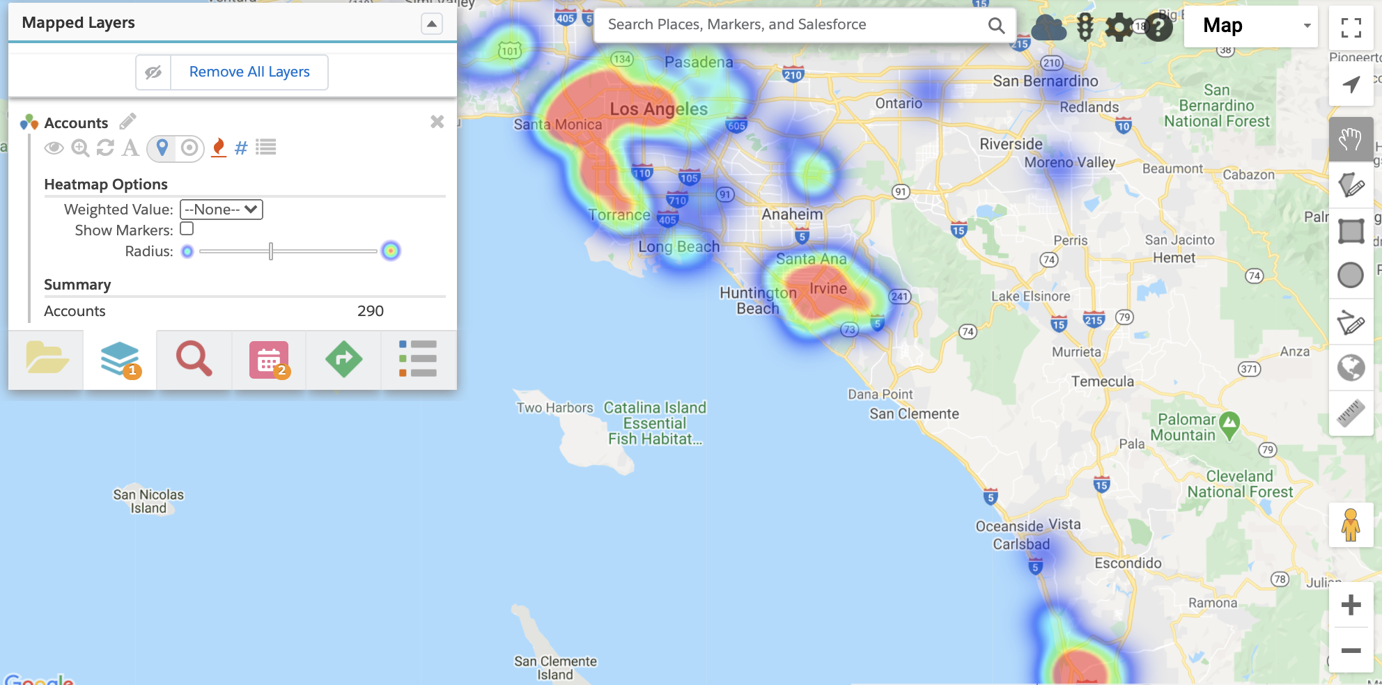
3. Pick a location for your next customer appreciation dinner
Before you set the location of your next customer appreciation dinner, do a little data analysis.
Geoanalytics software makes it easy to map out where your customer base is located and find a nearby venue that is optimally placed in the middle of high-density areas with heat maps. Visualize the locations of your customers on the map, rather than trying to scan through lists and spreadsheets to determine where the majority of your base is located.
4. Take notes and confirm your on-site visits
Some Geoanalytics software has mobile capabilities and includes check-in and check-out functionality. Especially for field technicians, check-in and -out features allow you to track activities in the field, taking down notes while they are top of mind. This ensures you can remember important information later on and improves the accuracy of your data.
Rather than trying to go back and log information about your visits for the entire day, you can take notes on-the-go. This also means your manager can see important or time-sensitive notes more quickly, so customer needs can be addressed sooner. Also, sales operations can perform analysis – such as calculating time spent at each location – to review for opportunities to increase efficiency.
5. Keep an eye on the competition
It can be difficult to keep up with competitors, but this is another area where Geoanalytics software can help. Use it to map out your competitors’ locations on the map. When you have competitors mapped out, you can display your open opportunities or at-risk accounts to determine if you should be worried about a competitor stealing your prospects and customers.
Another tactic is to map out the competitors of prospects that your sales team is chasing, and use the ones that are already your customers as leverage in your sales pitch. Being able to tell a prospect that their rival already uses your solution, implying that they will be left behind, can be a powerful motivator.
6. Plan your next marketing campaign
It sounds strange at first, but consider this use case for Geoanalytics software. Personalization is crucial now in marketing, and anonymous blanket-emailing isn’t going to cut it anymore. This means you need a way to better understand your customer base so you can create more targeted campaigns.
Data comes to life with the dynamic visual representation, and mapping is one way to visualize your CRM data. Use the demographics data available from most Geoanalytics software to inform your personas, targeting, event planning, and other initiatives.
With Geoanalytics software, you can map out your customers and filter your results by industry, employee range, or other custom fields to create messaging for a particular group. You can personalize and segment your promotional content geographically, and improve your understanding of what resonates with certain buyer types.
7. Balance territories and ensure no customer is left behind
As your business expands, you will likely have to increase headcount to keep up with all your customers. It’s important to keep an eye on your territories to ensure that reps aren’t overloaded with accounts and customers are beginning to slip through the cracks.
With Geoanalytics software, it’s easy to understand how adequately territories are being covered and if accounts and leads are equally distributed amongst your team. With a visual representation of data, you can easily design, analyze and reassign territories to distribute sales leads and opportunities.
Functionality that will help with territory management includes marker clusters and mass-updating records right from the map. Geoanalytics software enables sales operations teams to color pins by assigned owner, map open opportunities by potential revenue and map leads and prospects by size. From there, you can use mass updating of records to reassign these opportunities and leads to the correct owner of the sales territory.
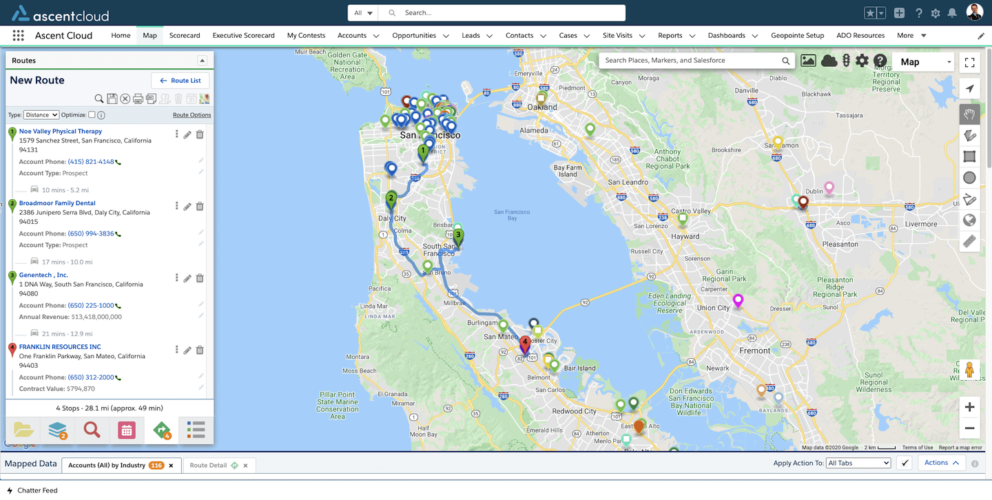
8. Prioritize your on-site visits and build your schedule for maximum efficiency
Adjust your schedule in real-time while you’re on the go. Geoanalytics software enables reps to plan multiple stops on an upcoming trip and the time it takes to travel to each, plus include a start and end times for each meeting. With built-in route optimization, you can be sure you’re making the most of your day and reducing travel time as much as possible.
On the other hand, Geoanalytics software enables you to fill in gaps in your calendar by identifying close-by accounts and adding these stops directly to your calendar from the map. If you’re already on the road and a client cancels last minute, you don’t have to waste that gap of time – just substitute with an extra stop that’s on the way.
This is especially helpful when traveling to a new, unfamiliar area.
9. Find the optimum location for your next branch
Franchises, banks, and retail establishments can use Geoanalytics software to uncover insights into customer behavior and optimize branch locations for maximum customer engagement. Take it a step further by overlaying demographics data to understand more about who your customers are.
Geoanalytics software also enables retailers to understand what locations are doing well in terms of sales, assess the viability of different locations for new storefronts, or show potential franchisees what locations are available nearby.
10. Keep track of your valuables and assets
Particularly for logistics companies or businesses that have assets in the field, Geoanalytics software can help make sure you know where your valuable property is at all times.
Live vehicle and asset tracking is beneficial for locating all your most important assets – including your people. Calculate drive time, estimated arrival times, and more using this capability.
![]()
Bonus: Looking for a solution that supports end-users who make regular, repetitive stops (i.e. consumer goods delivery, home health providers, etc.)? For Geoanalytics software, this requires additional capacity. Geopointe’s Route Planner saves your team time and helps you ensure your largest accounts get the attention they deserve while making sure your smaller accounts don’t slip through the cracks.
")

