
The CSV file format has been popular for decades as a way to maintain data and share it across systems. With the March 2020 release, now you can import CSV files directly to the Geopointe Map, opening up a world of data possibilities.
As long as your CSV file includes some address information (either coordinates or street addresses), Geopointe generates a layer of location-based points that you can save and load, just like other Map layers. You can bring the data to life with marker colors and other visual tools. Then it’s up to you whether to save the data to Salesforce, take actions on it, or use it to enrich your decision-making.
Turn Spreadsheets into Clear Plans of Action
CSV files can offer valuable information, but the spreadsheet format can be difficult to work through. With Geopointe, you can take a lengthy list, such as acquired leads, point-of-sale transactions, or contractors, then quickly identify geographic areas of focus, initiate follow-up, or otherwise take action on that data.
For example, a sales rep can take a lengthy list of acquired leads and immediately drill down to the ones that are most geographically-relevant or located in their territory. By applying marker colors, they can identify those that meet certain targets, or they can use the heat map tool to identify regional concentrations. Now they have a clear plan and can take follow-up actions, such as creating new records, building a route, or initiating custom action follow-up.
Apply Flexible Business Processes
The beauty of the CSV Layer feature is that it lets you decide for yourself what to do with the data. Unlike Salesforce’s Data Import Wizard, you are not required to import to a Salesforce object right away, and you can mix and match object types when you do. Using standard and custom actions, you can implement your own process on each data point based on your analysis.
This flexibility is a powerful tool for business planning. For example, imagine a team has a CSV file of potential shipping centers to work with and they need to identify and assign them based on their locations. Using Geopointe’s tools, they can map the shipping center locations, add relevant ones into Salesforce with Create Record actions, then assign them to accounts or take other actions to complete the business cycle.
Enrich your Perspective with Third Party Resources
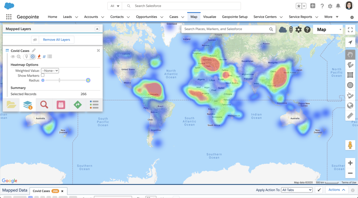
As one of the most popular file formats, there are endless CSV resources available from third parties. You can use any public data such as crime reports, real estate transactions, or health statistics, and layer them along with your Data Sets to get a full understanding of the potential values, challenges, and social conditions of an area.
This can be especially valuable in a time when up-to-date health statistics are essential for business planning. You can layer on publicly-available Covid-19 resources to get a clear picture of the state of public health risks and opportunities in an area. Empowered with this information, you can implement regional plans accordingly.


